 |
1821 Info 1g: Caleb Crompton |
Caleb moves to Victoria - an introduction
This page was first drafted in early 2002 when the facts then represented were thought to be accurate. They were augmented by James Crompton's photograph of St James' Church, which, at the time was the only church in the settlement and remains an important and memorable milestone. At that time it was thought that Fanny was buried in the grounds of the church. In the following 19 years many new facts came to light, especially following a visit to Tasmania and Miners Rest. There is still more to discover, however, links have been established with his journey to Miners Rest, the Newmarket Hotel and Dowling Forest race track.
It is still not known why Caleb first migrated to Adelaide, though it is known he travelled from Launceston to Adelaide with a quantity of hay. Whilst in Adelaide he dealt in horses, which involved financial irregularities and imprisonment in the newly opened Adelaide gaol. He tried to become a slaughter man before he was made insolvent and lost his properties in Adelaide and Cox's Creek. Perhaps, Caleb like many others, was lured to the Ballarat goldfields, discovered in 1851, on a overland journey seeking his elusive fortune.
Their third child, Charles Walter, was born on 7 April 1850 at Cox's Creek, Adelaide. His death certificate notes that he lived in South Australia for one year, until 1851. Perhaps, He arrived in Victoria in 1852 according to Frances' death certificate and to Miners Rest. Charles Walter's obituary of 25 June 1929 gives a clue about the journey from Cox's Creek to Miners Rest.
 |
 |
The extract from Charles Walter's obituary records that the family arrived in
the Ballarat goldfield by bullock dray known as a bullocky. In modern time this is a
distance of 586km and a bullocky time (average 5kph) of 117 continuous hours or 15
eight hour days.
Left: A composite image of The Record of Emerald Hill 29 June 1929 Source: Trove (Accessed: 11 February 2021) |
 |
| Above: Bullocky team crossing Bacchus Marsh, Ballarat Source: Bate p.10 |
His daughter Maralena's obituary describes her arrival at a tented village known, as Ballarat, at the time of the riots. 1
 |
|
Late on Wednesday evening the death occurred at 41O Creswick road. Ballarat, of Mrs. Madeline Macdonald, the mother of Mr. Charles Macdonald, of Horsham. Although for some time her health had been failing she was about as usual, and her sudden collapse came as a great shock to her family. The late Mrs. Macdonald was of a kind and genial disposition and since her husband's death, less than two years ago. she had lived with her daughter, Miss Annie Macdonald, of the Macarthur street State school. Mrs. Macdonald was horn at Launceston in 1845, and at an early age left with her parents for Adelaide. In 1852 the family travelled overland to Ballarat, when it was only a village of tents, and was in business here at the time of the riot. [...] |
| Source: Horsham Times, Tuesday 11 March 1924, page 4 (Accessed: 07 March 2021) |
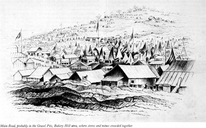 |
| Above: Main Road Ballarat c.1854, probably in the Gravel Pits Source: Bate p.43 |
Overland gold - the families journey to the goldfields
Gold was discovered in the Ballarat area in 1851. As the gold rush progressed and the number of people traveling from Adelaide to the Victorian goldfields increased, different routes were used of which two were the most important. The best known is the 'northern' route between Wellington SA and Horsham, Victoria, surveyed in early 1852 for the South Australian Gold Escort. In March 1852, to support this, wells were upgraded or dug, and water was therefore available at regular intervals, where it had not been previously. This route took travellers through the Long (Ninety Mile) of South Australia and Victoria's Little Desert and dry country, which caused difficulties, especially in the summer period. The longer southern route avoided the desert.
Whilst it is not known which route Caleb took, it is assumed he took the shorter, harder northern route and which this description is based. The following section gives an idea of Caleb's experiences.
The Old Mount Barker Road was part of a South Australian network to transport resources to Adelaide and consumer goods out to the rural communities. Routes, one of which passed through Cox’s Creek, were determined primarily by topography, the availability of water and convenient creek crossings. Inns, stores, such as Caleb’s, and hotels quickly sprang up along these routes, at intervals of a convenient day's travel apart. The average distance traveled each day by a bullock dray fully loaded with supplies or household belongings was approximately 8-10 miles (13 km) a day. As time went on, and with changes in roads and routes, these stopping points developed into settlements or slipped into history.
By 1852, a high proportion of grazing land in Victoria had been settled and 'squatters' tracks were being created between 'stations' and with market centres. The provision of services for the settlers, for instance a mail service, helped establish tracks, which subsequently became the route of the surveyed roads and many of today's highways and roads. By the late 1840s mail services had been extended along an established route via Buninyong through Burnbank (now Lexton), and along the northern side of the Wimmera River to Horsham.
Apart from any existing routes, wheel and stock tracks were often clearly visible and easily followed. There are references to signs nailed to trees as direction posts. By October 1851, trees were 'blazed' (marked) with an axe. Information and directions were passed freely between travelers and settlers in the various areas. The 'roads' were generally in a 'state of nature' with weather and seasons influenced their conditions. Creeks and rivers could become difficult to cross in winter or times of heavy rain and the desert was dry.
The new road began across the Murray River where members of the party helped to haul the Wellington punt, laden with several other drays, across the Murray River. During February 1852 the Wellington ferry carried some 1,234 passengers, 1,266 horses and bullocks, 164 carriages and £64 in fees was collected. Later in the year, during October and November 1852, the Wellington punt serviced 3000 passengers, 361 carriages and 2777 draught oxen. In early 1852, William Trevena, his wife Jane and six children with three of Trevena relatives and a fellow miner and his wife recorded his journey. They had two bullock teams and three horses, one of which was ridden most of the way. The horses and bullocks had to swim across the Murray River, while the families were paddled across by Aborigines in canoes. The bullock drays were pulled across the river by Aborigines on the opposite bank.
 |
| Above: Map showing the northern gold route with journal
recorded camp sites Click on the map to open a scalable pdf map in a new window Source: Adapted from Overland Gold - Cornish Association of Victoria |
In October 1851, diggers squatters and teamsters bound for the goldfields struck east from Wellington following a fairly straight route that was carved in the landscape. They followed the aboriginal tracks from native well to well to ensure a good water supply and to avoid unnecessary river crossings: between the few lonely cattle station; through the deserts; following streams. The trail went by way of Cooke’s Plains to Binnie’s, where it divided into the northern and southern route.
Based on the information provided by Sergeant Rose, a policeman who for the preceding two years had been stationed at Mosquito Plains (McIntosh’s Station), and who was ‘acquainted with the whole country between Adelaide and Mt Cole, Deputy Surveyor-General McLaren’s team survey the route. The report refers to their objective of ensuring water was available every 12 miles.
Between January and February 1852, McLaren’s team surveyed the easy track along the Wimmera River. This became the main Wimmera road, which could be followed upriver across to Burnbank, then south-east to Geelong. It became a track for supplies, loads of wool and the over-landing diggers.
At this time, John Kentish and his mate George claimed to have made the first crossing with bullocks. Their dray carried 'a tent, bedding, provisions, mining tools, two single barrel guns, a pair of old-fashioned horse pistols, and a large supply of ammunition'. In the days before the establishment of wells, in '[c]rossing the South Australian desert, they took it in turns to scout ahead for native wells or soaks. After clearing the scrub, they had to force the bullocks over 30 miles in one day to the next watering point, where the exhausted animals had to be rested for several days' They saw several 'jaded and half-starved' horses abandoned. They lived 'quite well off the country' and 'several times met small groups of Aboriginal nomads.' Trevena recounted the troubles associated with the long drive through the ‘ninety mile desert’ (Binnie’s Lookout now Coonalpyn Downs), the difficulties of crossing the River Loddon which was so rough the bullocks could not get a footing, and tedious daily progress that lasted for seven weeks before the party reached Bendigo.
On 10 February 1852, a special armed detachment South Australia police, led by Alexander Tolmer, followed McLaren’s 360 mile trail through dense scrub and desert route, to provide a ' Gold Escort'. Tolmer provided observations on terrain, water, river crossings, locations, land holders. On 5 March 1852, the Gold Escort left Castlemaine/Bendigo and securely carried 5,199 ounces (150 kg) of gold overland from the western Victorian goldfields to Adelaide, arriving two weeks later. The eighteen ‘Gold Escort’ trips made between 1852 and 1853 set the route and established wells.
Sources:
The Newmarket Hotel
In the early years, Miners Rest boasted seven licensed premises and hotels, having been camping sites for miners en-route to the Ballarat gold diggings, with a 1861 census of 126, Three hotels had horse racing names, including the Newmarket Hotel, in the original Miners’ Rest, on the corner of Howe Street and Cummins Road, included the Cobb and Co. stables. Built in 1856 at what is now 135 Howes Street, at the corner of Howe Street and Cummins Road, with the now demolished Cobb and Co. stables adjacent. Established as a wooden building before December 1854, the Newmarket was the original and popular resting place half-way between the two newly discovered goldfields at Clunes and Buninyong. It was recorded in the 1903 Australia Handbook. It's license was revoked in 1909.
The Federation University Australia at Ballarat (Accessed: 04 January 2019) lists as licensees/owners of the Newmarket:
Clearly, no one had heard of Caleb's ownership in a year before the accepted build date. Caleb's possession of the Newmarket is recorded in the report of yet another insolvency.
|
| 1 | 2 | 3 | 4 |
|---|
 |
 |
This time on 08 December 1854, shortly before his death, the Newmarket, already
described as a wooden building, placed on two roods of land (½ acre), is being
sold at auction for the benefit of James Cairns of Lonsdale Street, Melbourne.
Left: The Argus of 08 January 1855 reporting the pending court case |
Cobb & Co. stables 137 Howes Street 3
Bill Loader, Learmonth Historical Society researcher, laden with an armful of his records, showed us round Dowling Forest Cemetery and to whom I am eternally grateful. On the Stables, he is recorded as saying “They changed the horses there as they were going through to Clunes. It was an important stop and I suppose, with the hotel, it would be a stop for the passengers, too. They were the only stables left standing on the route, so I suppose that would make them fairly important.”
In 2012 the then owners the Murphy family sold the lot splitting the property into three different lots, separating the stables and hotel and including provision for the stables to be kept, accessed and re-used. The property was sold and the new owner had the property further subdivided into three lots.
The Newmarket Hotel stables stood in Miners Rest for 158 years and was part of the story behind the town’s name, before they were demolished without permission. The person, who Ballarat city said it could not identify, was eventually fined just $3000 for tearing down the stables of the Newmarket Hotel. The city initiated legal action against the person over the demolition, but then agreed to a diversion order instead – an alternative to usual court proceedings that allows for the settlement of charges without a conviction. "At the end of the day, the building should still be there. It's inexcusable that it was pulled down," Mr Schinck of Ballarat Council, said. If the new owner of the stables had followed correct procedure, they would almost certainly have been saved.
|
1. Bill Loader at the site of the Stable with a George Flewin 4
brick that built the stables - The Chronicle, Ballarat 2. Cobb & Co. stables exterior - Bill Loader |
3. Cobb & Co. stables interior - Bill Loader 4. The demolished Cobb & Co. stables - Bill Loader |
| 1 | 2 | 3 | 4 |
|---|
Source: The Courier Ballarat, 20 September 2014 (Accessed: 2 January 2019)
Note: George Flewin, the brick maker, married Jane Betsy Blackman, born Wilmington, Kent in 1826 and died Ballarat 25 March 1901. Possibly the sister of John Blackman, born 1821 and progenitor of the Blackmans of Miners Rest clan.
 |
The photograph taken in 1896, shows the Grand Junction Hotel, situated at the junction
of the Clunes Road and Learmouth Road, Miners Rest. It was one of the more substantial
buildings of Ballarat, being two stories, brick built and with a large ballroom on the
upper floor. Because of the nature of the building and its proximity to Dowling Forest
race track the Grand Junction was a possible site for Caleb's inquest. Source: With thanks to Glen Crompton, late Mayor and now Councillor of Ballarat, whose great grandfather once owned Henderson's Grand Junction |
Dowling Forest Racecourse
The sheer drudgery of gold prospecting required an outlet, sparking many sporting and music alternatives. The Ballarat Turf Club, as the successor of the Ballarat and Creswick Race Club began racing in 1853, (commenced in Dowling Forest on 8 November 1854) It has a reserve of 486 acres in Dowling Forest properly laid out as a course, with grandstand and other buildings. 1 The racecourse revived the early fortunes of the settlement. On 16 December 1856 the first recorded “trotting match” took place as part of the Ballarat and Creswick Race meeting. The Victorian Amateur Turf Club, staged its first race meetings at Dowling Forest in 1875 before transferring to Caulfield, Melbourne. Ballarat Turf Club has a long history of steeplechase events. The Ballarat Racecourse has occupied its current site at Dowling Forest since 1972 and is now one of Victoria's major thoroughbred training centres.
1 Source: History of Ballarat (1887 Project Guttenberg Australia Accessed: 21 January 2019)
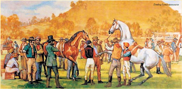 |
| Above: An undated Dowling Forest meeting Source: Ballarat 150 Australia's first trotting club p.7 (Accessed: 21 January 2019) |
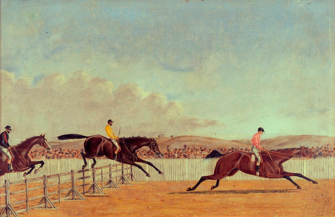 |
| Above: Adam Lindsay Gordon at Dowling Forest racetrack,
1869 by Thomas Hamilton Lyttleton, 1826-1876 Source: Trove (Accessed: 21 January 2019) |
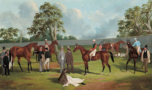 |
| Above: Group in the Dowling Forest Racecourse enclosure,
Ballarat, 1863 - Frederick Woodhouse (1820-1909) Source: Wikimedia Commons (Accessed: 21 January 2019) |
Dowling Forest Racecourse - November 2015 (Author)
Today, the race course can best be described as spacious, with its long tree lined drive and well groomed lawn areas and gardens. The large comfortable Grandstand has Public and Members areas linked by a fully enclosed betting area.
 |
|
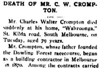 |
Left: An extract from the obituary of Caleb's son, Charles Walter, recording that Caleb was a founder member of Dowling Forest racecourse, located at the foot of Mount Pisgah, an ancient small lava dome. |
Footnote- the original Dowling Forest homestead
This 40,000 acres homestead was built by William Clarke and named after his bride's maiden name of Dowling. There is a strong possibility that the old house of "Dowling" still stands, nearer the Dowling Forest Cemetery than Miner's Rest, and that the farm is now ' the old Walton farm'. 'Big' William Clarke was asked to fund the building of the now venerated Ballarat theatre - 'Her Majesty's'.
Caleb's death
Family hearsay always recorded that Caleb died an accidental death, falling from his horse, suggesting a letter had reached Nafferton. Many years later this information was confirmed by the Victorian Inquest Index for 1840-1985 and by the inquest papers:
Name:       Caleb Crompton
Place:      Dowling Forest
Year:       1854
Ref.:       736
Sex:        M
Cause:      Accident
Occupation: Adult
The inquest papers record his cause of death as "accidental death by a fall from a horse, deceased being at the time intoxicated". There does appear to be some testimony missing. Why wasn't he missed by Frances and family, none of whom took part in the inquest, nor were they mentioned?
On 29 December 1854, Caleb decided to go to the race meeting at Dowling Forest (a small settlement just outside Ballarat), leaving home about noon, after borrowing some money from his partner, Alexander Sangster. He was seen in the tent of Thomas Fletcher, store keeper, the evening he died and was expected back that evening, but wasn't missed, by Sangster, because he thought that Caleb might have gone to the race dinner in Ballarat. His body was found on the road near the race course just after nine o'clock the next morning. His dented hat and one horse was found in the bush nearby. According to one of the jurors at the inquest, Caleb "was rather given to drinking".
| Many editions of the 'Ballarat Times' dated between August 1854 to November 1867, which may have commented on Caleb's inquest, are missing. However, the newspaper of January 1855, located in Ballarat Library, was a Post Office advertisement listing the names of people who had not collected their mail. A letter for Caleb CRAMPTON had been waiting for him since November. The dialect spelling of his name suggests that this letter had not come from his family in England. |
 |
|---|---|
Click on the image for a 600x3300 pixel, 530Kb full picture. |
'The Argus', the Melbourne paper of the times, of 26 December 1854 didn't mention the Races on that day, nor was there a report on 27 December 1854. There were a number of inquests reported on 30 December 1854, but nothing on Caleb. However, there were more comments on the Crimean War and the fight with Russia.
 |
|
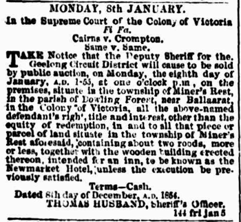 |
On 15 December 1854, in column one of page 3 , of The Argus gave notice
that a Mr Cairns was suing a Mr Crompton for all that he possessed. The location of
Miner's Rest (with a possessive apostrophe) and the connection with selling alcohol
suggests this is our Caleb.
If so it is interesting to note that his building, made of wood and termed a hotel, was placed on two roods of land (½ acre). It may be possible to trace this land grant and therefore the location of the Newmarket Hotel. The same legal notice also appeared on page 3 on Thursday 21 December 1854, eight days before his death and 2 January 1855. Is there a connection between this notice of bankruptcy and his death? Source: Trove Digitised newspapers Accessed 17 September 2015 |
 |
|
 |
This notice, posted on page 8 of Melbourne's The Argus of 19 January 1855,
21 days after his death, suggests that Caleb died intestate, so requiring Frances to
appeal to the Courts for his effects. The advertisement confirms his occupation as that
of 'inn keeper'.
Had Mr Cairns legal case collapsed with Caleb's death thus allowing Frances to claim his belongings and a degree of financial security? Source: Trove Digitised newspapers Accessed 17 September 2015 |
Despite Frances' petition page 8 of The Argus of 22 February 1855 reveals a counter claim from James Cairns of Lonsdale Street, Melbourne, who appears determined to recover his lost money.
 |
||
 |
When, on 10 December 1849, Caleb had declared himself insolvent, in Adelaide SA, the
same James Cairns had been the plaintiff. Caleb explained ‘that he had been entrusted by
p?tt? in Van Diemen's Land with horses to sell on their account in South Australia. He
made no return for the horses he disposed of except £20 (£1250 in 2014) and for that he
admitted he received a consignment of apples. He sold, bartered, and exchanged the horses
for various kinds of property, and after trading some time purchases a section of land
containing thirty-six acres, ten acres of which he said (??? stated) before he has seen
the land. He built a house on the ten acres he sold and finally became insolvent.’
The first notification, which appeared on Monday 12 February 1855, named Frederic Bayne, of 64 Chancery lane, Melbourne, as proctor for the said James Cairns. It is interesting to note that Caleb is 'late of Geelong'. Source: Trove Digitised newspapers Accessed 17 September 2015 |
|
With thanks to Warren Power in Creswick, Victoria, for researching the 'Ballarat Times'.
Caleb's burial place
There can only be speculation about where Caleb was buried. His name does not appear to be in the Old Dowling Cemetery, which opened in 1859. Facts such as Burrumbeet church being nearer Windemere and that the Windemere Church is nearer Cardigan serve to show how difficult it is to tracing things from the gold rush days. Cardigan never had a church - it would probably have been at Miners Rest. Both these churches have burial grounds that are candidates.
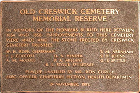 |
Left: Marker plate at the Old Creswick Cemetery
Heather Schoffelen suggested that the Old Creswick Cemetery may be Caleb's last resting place. |
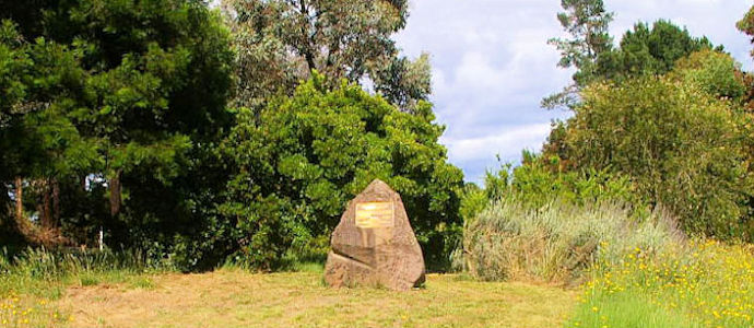 |
| Above: The marker stone at the Old Creswick Cemetery |
Miners Rest - an historical background
Miners Rest is a township 12km north of Ballarat. In the early 1850s, Miners Rest occupied a strategic location, being midway between the then recently discovered goldfields of Clunes and Buninyong, and was on the Burrumbeet Creek, a source of permanent and flowing water. It was established before Ballarat. It is thought that the name is descriptive of its location and also signified its role as a resting place, with many hotels and other accommodation houses providing respite on the route from one goldfield to another. Despite its proximity to Ballarat and Clunes, Miners Rest was not a prominent mining area. Its undulating landscape, including several bald hills and a flat area, which became Dowling Forest race course, made it suitable for agriculture. The small township was therefore established before Ballarat and was first surveyed in 1854.
The discovery of gold in Ballarat in 1853 rapidly changed the function of Miners Rest as an important resting place to and from Clunes. The town became a service centre for the surrounding agricultural district and horse racing industry.
A school opened in 1858, at about the time when the Ballarat Turf Club transferred its race meetings to Dowling Forest, about 1km north-west of Miners Rest. In 1865, Bailliere's Victorian Gazetteer recorded Miners Rest as being almost entirely cultivated, apart from a few places being sunk for alluvial gold leads. There were seven hotels in the district, three with horse racing names, with the town having fewer hotels. By 1880 there were three churches. During the 1920-70s Miners Rest experienced a gradual loss of rural population. The railway line through the district to Warubra closed in 1968. Towards the end of the 1980s Miners Rest became a rural dormitory suburb for Ballarat. The town had a general store, a hotel, a modern supermarket, a single Uniting church, a mechanics institute (1898), a quarry and a recreational reserve. The Dowling Forest racecourse was still the venue for the annual Ballarat Turf Club meeting and had held meetings for the whole of the Ballarat district and for the Ballan Jockey Club since 1969.
The census data records 1861:126, 1881:439, 1911:360, 2011:2542, with a school enrolment of 216 in 2014.
 |
Left: Miners Rest from the 1903 Australian Handbook, which draws attention to the Newmarket Hotel, Dowling Forest Racecourse and the churches, including the Wesleyan |
| Right: Site of the Wesleyan Church which was directly opposite St James' | 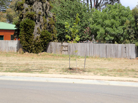 |
 |
| Above: An 1854 map of Miners Rest with an overlay of modern roads in yellow. The streets of Miners Rest have been renamed and renumbered over the years. Changes of street names are in brackets. |
Miners Rest today
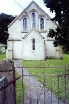
St James Uniting Church Miners Rest
| The marriage certificate of Caleb and Fanny's fourth
child, Frances Emily, gives Daisy Hill as her place of birth. This must have been Caleb
and Fanny's residence in 1852 two years before Caleb died. Daisy Hill is 50km from
Miners Rest, south of Maryborough. Elizabeth Emily Milner CROMPTON's marriage
certificate, of 1867, would suggest that Caleb was attracted to Miners Rest to provide
the services of publican.
This was my first and iconic picture of Miners Rest and I would like to think at least Fanny attended services there. Right: St James Church Photo James Crompton 2005 |
 |
|---|
Designed by Architect Joseph Doane and built in 1859, the doors of the St James Uniting Church, at 10-12 Creswick Street Miners Rest, closed for the final time on Sunday 31 May 2009. The final service came just months before the congregation was due to celebrate 150 years of worship. People came from all over Australia to the little church for the celebration, which was followed by lunch and exchanging of fond memories. When the property, was sold in March 2011for A$325,000 and A$520,000 on 06 July 2018, it had a frontage of 40.24m and depth of 100.58m.
|
1. St James' unknown date 2. St James' unknown date |
3. St James' as a functioning church 4. St James' rear |
| 1 | 2 | 3 | 4 |
|---|
| 5. Under restoration November 2015 Author | 6. St James' restored to holiday let 2018 |
| 5 | 6 |
|---|
The interior of St James' Church - unknown source received April 2005
|
1. Notice board 2. Front of the school |
3. Front of the school 4. School looking east |
| 1 | 2 | 3 | 4 |
|---|
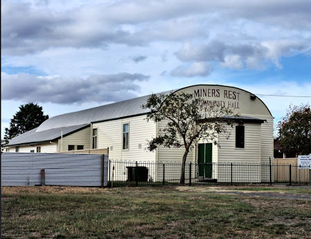
| The original features of the Miners Rest Community Hall are over one hundred
years old, including an open fireplace. Today the hall is used regularly by the local
community with activities such as Landcare meetings, Lions Club meetings, morning
teas, Yoga and exercise classes and private functions. The hall seats 100.
Right: Miners Rest Community Hall and playgroup situated at 2 Market Street in 2015. Originally the Mechanics Institute |
 |
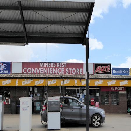 |
Left: Miners Rest store off Raglan Street Author: November 2015 |
Sources:
Leslie Crompton BLACKMAN on the Miners Rest War Memorial
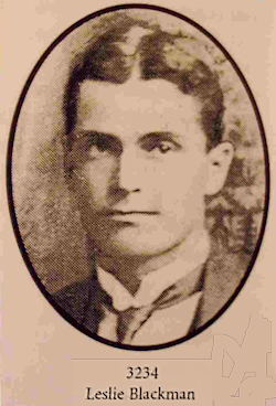 |
Leslie Crompton BLACKMAN, an employee of the Melbourne Gas Company, was the
sixth child of Frances Emily CROMPTON and William BLACKMAN. He was killed in
action at Ploegsteert Wood, Belgium with the 5th Battalion on 29 June 1916.
Click here to go to his page.
Left: Leslie Crompton BLACKMAN c.1914 |
| Hoverbox Photo Gallery - Miners Rest War Memorial This feature does not function correctly on phones and tablets |
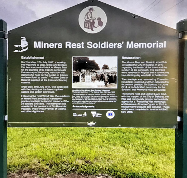 |
| Above: Miners Rest Memorial Board. With thanks to Heather Schoffelen |
| Establishment On Thursday, 12th July 1917, a working bee was held to clear, fence and prepare this two acre central block in Miners Rest for the planting of 63 trees to perpetuate the memory of the young men from the district who "took on the burden of Empire and went forth to battle". The then shire of Ballarat supplied all the trees and fencing material. Arbor Day, 19th July 1917, was celebrated with the planting of trees - golden wattle and golden cypresses. Following the First World War, the residents of Miners Rest erected a "handsome granite cenotaph to stand in memory of the 24 soldiers who died. The memorial was unveiled in the presence of Sir Alexander Peacock, three time Premier of Victoria and other dignitaries. |
Unveiling of the Miners Rest Soldiers'
Memorial Photograph published in the Ballarat Star, 29th May 1920. "The monument is of Harcourt colonial granite, with bronze face plates, and contains the names of twenty-four soldiers of the district who made the supreme sacrifice. The monument was designed by the well-known sculptor, Mr F.W. Commons and the work executed by returned soldiers employed at his works, Creswick Road, Ballarat. |
Restoration The Miners Rest and District Lions Club contacted the City of Ballarat in 2013 regarding the health of the trees and the location of the cenotaph. The old trees were removed in August and a community planting tree-day was held in September. The cenotaph was removed by the Council in November, restored and then relocated to its present position. On Sunday 1st June 2014, a re-dedication ceremony for the Soldiers' War Memorial was conducted. The Miners Rest and District Lions Club with the support of the City of Ballarat, the RSL and community groups, successfully applied for a "Restoring War Memorials and Avenues of Honour" grant in 2015 to replace the name plaques and signage. These works were completed in time for ANZAC Day, 2016. |
| More information 1 |
| More information 1 cont: |
| More information 1 cont: |
| The engagement was brief. Five attackers died and twelve fell seriously wounded.
Thirty diggers died of whom about half were bayoneted after the fortifications had
been over run. A shock wave of opinion in the Victoria press shattered government
complacency. Ballarat was angry but not cowed. On Monday, under arms garrison escort,
the coffins along the Creswick Road to the Old Ballarat Cemetery.
Note: Albert James CROMPTON (1876-1929), the author's great uncle, was chauffeur to John Hotham (1836-1907) the 5th Baron Hotham of Dalton Hall, South Dalton, East Yorkshire. Sir Charles Hotham (1806-1855), then Lieutenant Governor of Victoria, was born in Dennington Suffolk. Whilst there is no direct link between the two families, it is suggested they must be related based on the fifth Baron dying childless. He was succeeded by his first cousin once removed Frederick William Hotham (1863-1923) Source: Bates, Weston, Ballarat Lucky City, The first generation at Ballarat 1851-1901, Melbourne University Press, Carlton, 2003 edition |
| More information 2 |
The gold route in more detail
If taking the northern route, Caleb would have passed through the following locations.
|
| More information 3 |
| Cobb & Co.
The original Cobb & Co was established in Melbourne in January 1854 at the height of the excitement created by the Victorian gold rushes by four newly arrived North Americans - Freeman Cobb, John Murray Peck, James Swanton and John B. Lamber to convey mail and passengers between the port of Melbourne, and the Victorian goldfields. The first Cobb & Co. coach completed its maiden voyage – from Collins Street, Melbourne to the Forest Creek diggings (now Castlemaine) – on 30 January 1854 in half the time of its competitors. Within months, the firm’s reputation for speed and efficiency was running the competition off the road. At the time, most coaching companies were using English vehicles, which had heavy, rigid bodies and stiff metal springs – perfect for the paved and genteel roads of the mother country, but totally unsuitable for the rugged Australian landscape. Freeman instead imported Concord coaches, which had been designed for travel in the American West. They had rounded, lightweight and supple bodies resting on leather straps called thorough braces. The result was a much smoother, faster ride – although the back and forth rocking motion of the carriage prompted one passenger to liken the experience to riding “a baby camel in a hell of a hurry”. At first they traded as the "American Telegraph Line of Coaches," a name that emphasized speed and progressiveness. They arranged the importation of several US-built wagons and Concord stagecoaches. By early 1854 Cobb & Co operated a daily service to Forest Creek and Bendigo and, soon afterwards, expanded the service to Geelong and Ballarat and other goldfields. The second reason was Cobb & Co.’s placement of changing stations every 10-20 miles (16-32 km) or so along their routes often at inns or hotels that could cater for the drivers and passengers. Fresh horses meant the coaches could maintain high speeds across long distances. The grooms at each changing station were just as vital to the success of a coach trip. Each was responsible for 8-10 horses, as well as the upkeep of each animal’s made-to- measure collar and leather harness. The driver would sound a bugle 1 mile (1.6 km) out from the change station to alert the groom, who would have the fresh team brushed and harnessed by the time the coach rolled in. It was an innovative and winning combination, and by the time Freeman Cobb and his partners put the company up for sale in 1856 it was reputed to be worth £16,000 (equivalent to about A$2.1 million in 2011). Within a few years, Cobb & Co had established a reputation for efficiency, speed and reliability, although they had not won any of the lucrative mail contracts. Instead of competing with the railways Cobb & Co coaches were transferred to feeder routes and were timetabled to link in with trains." Sources: Wikipedia (Accessed 13 January 2019) Cobb & Co coaches: historical transport (Accessed: 13 January 2019)
|
| More information 4 |
| George Flewin - brick maker
George Flewin was born in Wilmington, Kent, in 1824. In 1845 he married Jane Blackman 1845 (GRO ref: Dartford 5 201 as Fliven), who was born in Kingsdown in 1826. They left the UK via London and arrived in Port Phillip Bay on the ship "Glasmerden" George died on 5 October 1919, aged 95 at 143 Creswick Road, Ballarat and is buried at Dowling Forest. Jane died on 27 March 1901 at Miner's Rest. George and Jane's son John, was born 1846 in Wilmingron. Their daughter, Ellen was born in Victoria in 1858. John died in Morwell, Gippsland, in 1926. John worked with his father at Miner's Rest before he moved to Morwell and had his own brick business. The brickworks were established in 1888s. He and his wife, Margaret had several children, many lived all their lives in Morwell or district. With thanks to Heather Schoffelen |
|
 |
|||||||
| This page was created by Richard Crompton and maintained by Chris Glass |
Version A24 Updated 23 March 2024 |
|||||||